Boldt Castle
For all the kayaking I have done over the years in the 1000 Islands region of the St. Lawrence River, I had never yet visited what is likely the areas premier tourist attraction, namely Boldt Castle. So today being another of those gorgeous late fall weather days I planned to remedy this by planning a kayak trip from Rockport that would take me around Heart Island, home to Boldt Castle and then a circumnavigation of Hill Island paddling the yet to be explored (by me) channel lying between Wellsley Island and Hill Island.
For those of you not familiar with this extraordinary landmark, the castle was the brainchild of George C. Boldt, erstwhile millionaire of the Waldorf Astoria who commissioned its construction as a lasting display of his devotion to his wife. Construction halted on the untimely death of his wife, broken hearted he never returned to the island leaving the uncompleted castle to fall into disrepair until 1977 when renovations were begun which culminated in the fantastic example of a Rhineland castle that exists today, playing host to millions of tourists every year.
 |
| U.S. waters |
The day promised to be perfect for paddling with plenty of sunshine, light wind and an expected high of 12 c. Loading the boat on the roof of the car I wore gloves as Jack frost was very much in evidence requiring me to run the engine for awhile to clear away a heavy frost. As Heart Island is within the U.S. I downloaded a map of New York state which I loaded on my GPS, unfortunately I can't view or print both my Canadian topographic maps and New York map simultaneously so here they will appear separately although my track can still be seen running off into the missing maps. By the time I am ready to depart Rockport; 11:15 it has warmed up nicely and I set course for the NE tip of Wellsley island the start of U.S. waters a distance of 2 km. From here I will loop southward and around Heart Island before returning to this point to begin a SW course between Wellsley and Hill islands.
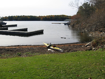 |
| Launch from Rockport |
From the git-go it is obvious the water levels are greatly reduced from what I think of as normal and as I pass through the bay east of Wellsley it is very shallow. I get my first view of the keep and an other large building on an adjacent island which in profile is somewhat reminiscent of Westminster Abbey. This turns out to be where you keep your 3 masted sailing ships when you are not using them.
 |
| Boldt Castle |
 |
| Yacht House |
Heart island is rife with Maple trees which at this time of year are ablaze with colour; this helps mitigate the extravagant use of medieval ornamentation. Of course castle owners should always have a little guest castle in case the family drop in, actually I think this was built as a play house.
 |
| Guest Castle? |
 |
| Ornamentation |
As there is no sign of Rapunzel to offer me an invite it is time to continue my journey and get back to Canadian waters; cause ya can't go for a 'P' in the U.S. without a passport! If medieval is not your thing the neighbours a few islands downstream, offer an attractive alternative for the not so filthy rich.
 |
| The neighbours |
The castle is closed for the season and some maintenance appears to be in progress. There is quite extensive docking facilities to accommodate the steady flow of tour boats that bring those millions of tourists and as I head back I am passed by two vessels obviously making a drive by. One from Gananoque, the other Rockport.
 |
| Gananoque Boat Lines |
Hill Island
 |
| Hill Island circumnavigation |
As I turn SW I enable my Topo Canada map once again, and if I stay close to the shore of Hill Island I will remain in Canadian waters. First order is to find a suitable place to stop and have lunch etc. I don't have to wait long, a small uninhabited isle just offshore of Hill with a shallow easy approach presents itself. The whole channel appears to be very shallow so I am not likely to see any other vessels.
 |
| Lunch stop |
Lunch over I continue SW almost straddling the international border and wondering what water conditions may lie ahead. I did a little reading online and found a blurb by Parks Canada that said conditions around Georgina and Hill islands were best suited to advance paddlers which I don't consider myself to be; experienced yes, but advanced I think of someone keen on rolling etc. I have been around Georgina and you do get strong currents and eddies but with low water I'm thinking this should slow things down a tad.
 |
| narrowing |
 |
| Skydeck Tower |
The
Rounding the corner I get my first view of the Skydeck, now renamed simply 1000 Islands Tower. As the channel narrows more, the water is getting shallower and in some spots it is not clear which way continues and which is a dead-end. Docks and speed limit signs indicate it is not always so! Another bend and I'm at the very short International Bridge, with Canada Customs just along to my right and the beginning of U.S. Interstate 81 to the left.
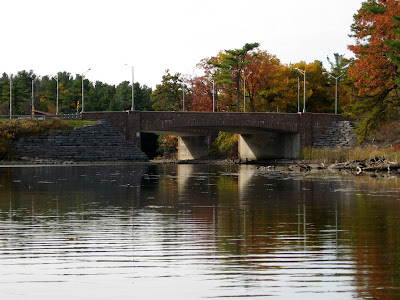 |
| International Bridge |
I am now in the last stretch which continues to narrow till finally there is a gap of around 5-6 m where it is deeper and one can see ripples of fast flowing water. It is manageable but requires some fast paddling to stay ahead of the flow. I can imagine in summer that this could be a bit of a challenge. Beyond this the channel gives way to open water and in the distance I can make out what I believe is a nav light on Lyndoch or Lyndoe Island reputed by some to be the onetime hideout of the pirate Bill Johnston. It also marks the entrance to Fiddler's Elbow a channel known for fast moving water. I make a first right which is the shorter route to Georgina Island as I wish to take out in good time and not be roaming in the gloaming although with being so sunny I doubt that a possibility.
 |
| final narrows |
 |
| back in open water |
From here on I am on familiar territory and head toward the south side of Georgina which is directly below the Ivy Lea bridge, then continue downstream along the north shore of Hill then Club island before cutting northwards back to Rockport.
 |
| Ivy Lea Bridge |
 |
| Georgina Island |
Along the way I stop and photograph this lovely Victorian house which would be more my style should I ever become a lottery winner. Complete with "widow's walk", I can just imagine the wife pacing about up there waiting for her knight in shiny neoprene to come kayaking over the horizon.
 |
| Victorian home |
On reaching the tip of Club island I swing north across the river and head in to Rockport. As I approach there are two divers just packing up their gear and we stop and chat. From them I learn that they pay $10 parking fee for the day so presumably a kayaker can do the same. As there was a few vacant spots by the grass I just parked and hoped it would be okay, it was!
 |
| Rockport church |
 |
| landing at Rockport |
This was a most enjoyable paddle, 22 kilometers in weather that couldn't have been much nicer. And as I write this the day after, the weather is crap, torrential rain! You have to grab them when you can. Another plus, from Rockport I take the 1000 Island parkway home which gives me yet another opportunity to enjoy the river from a different perspective. Don't mind Pancho, he is always muscling in on my pics!
Happy Kayaking!


